The autumn I first began Sonlighting, I eagerly read through my Instructor’s Guide, excited to see how literature-based geography would work. But when I reached the section on mapping, I read through the instructions again, sure I’d missed something.
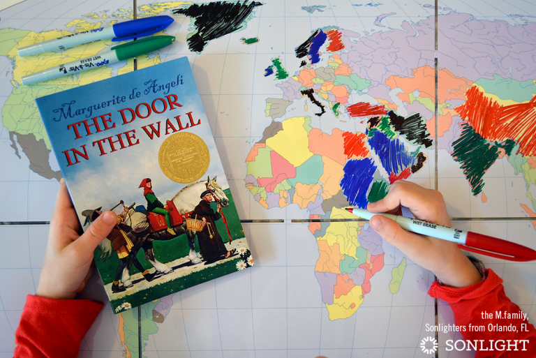
“Look for the globe symbol on the schedule page and in the notes. Use the coordinates and the location name in the notes to find each location on the laminated colorful maps in the front of the guide. Then, have your children note each location on your blank Markable Map using a washable pen.”
That’s it?

I was skeptical; marking something on a map seemed far too simple to actually work. (I tend to overcomplicate things. You, too?) But I tried it anyway.
Mapping Helps Kids Make Connections
Not long into our maiden Sonlight voyage, the following exchange took place between my Level A daughter and me:
Me, reading aloud: "The Vikings came from Norway, Sweden, and Denmark..."
Daughter: "I WILL FIND IT ON MY MAP! I KNOW ABOUT NORWAY!!!! I SAW IT ON THE MAP! MAY I HAVE A DRY ERASE MARKER?!" [Pardon the capitals. This is a true representation of my daughter’s volume.]
Me, reading aloud: "They were great sailors and traders, but they were also fierce warriors. They attacked and robbed villages...."
Daughter, covering hands with face: "Oh no. Oh no. They were fierce. Oh warriors...EUROPE! I WILL FIND IT ON MY MAP!"
Me, continuing to read aloud: "A Viking longship..."
Daughter: "I will draw it! I will draw one! I will draw a ship!"
In that exhilarating moment, I became a believer in the literature-based geography method. We’d done nothing but faithfully mark our maps, and already my kindergartner was making tangible connections between people and places. Historical figures leapt off the pages and across maps—from locations she’d never even heard of before—and made their indelible imprint in her memory. And do you know why? Because literature had made it possible for geography to come alive. We’re deep into Level C now, and my daughter’s knowledge of geography—in context—continues to impress. (Have you listened to the Geography Songs?)
Mapping Takes Less than Five Minutes
You’ll need to store your Markable Map and markers in a handy spot, of course. (If it’s folded up in the bottom of a storage bin, you’re not going to want to dig it out.) Once your map is accessible, the actual act of marking the locations takes almost no time at all. And the more you increase your familiarity with geography, the less time it will take. Some days, it takes us less than one minute from start to finish to mark the places mentioned in our reading.
Mapping Physically Helps You Remember
Even in the age of digital navigation and apps, there has been much research on the neurological importance of writing down information by hand. Students who physically wrote, discovered a recent study, far exceeded their digital-note-taking peers in the ability to make abstract connections. Fascinating studies link color usage with memory. What great motivation to keep marking your map and writing by hand!
Mapping Provides Context for Culture and History
A traditional geography course will help you locate capitals and countries and landforms, but Sonlight’s literature-rich method of mapping does much more. Because literature-based geography is taught in conjunction with history and literature, geography isn’t learned independently, but rather it's learned in the context of culture. Kids will gain a sense of the people who have lived and the events which have taken place in a particular spot on the map, rather than just being able to locate a spot on a map out of context. This makes geography so much more rich and memorable than if they were merely plotting points!
Mapping Creates Visuals of Ancient History in Modern Lands
Timelines are crucial in developing an understanding of what was happening in different parts of the world at the same time. Mapping, on the other hand, is essential in understanding what has happened over time, in the same part of the world. Unlike the linear presentation of a timeline, mapping creates rich layers upon which we can build a deeper understanding of the world. When a mapping exercise reveals that ancient Assyria is located across modern-day Iraq, Syria, Turkey and Iran, this bit of information boosts our insight into current events, too.
Mapping Provides Insight into Blind Spots in News Coverage
This last one isn’t strictly Sonlight-related, so I’ll call it a bonus. I encourage you to take the news mapping challenge and track each location you encounter in the news. Marking the map each time you hear a place mentioned can have a surprising effect. Not only will you see which regions get the most press, you’ll also begin to get a clear visual of your own blind spots in news coverage. This can be a very eye-opening and sobering experience.
Once you’ve found your mapping groove, you might even find yourself marking the map with locations from your leisure reading and conversations, too. What a wonderful way to build a lifelong habit of international and cultural awareness—and it all starts with using your Markable Map.
The Markable Map is a Required Resource in every Sonlight History / Bible / Literature program from K—W. Go to SmoothCourse to start your literature-based geography explorations today.


I love the idea of mapping places covered in the news. My kids are in their teens and this is something that would benefit them (and me!) Thank you for the suggestion!